
Make a donation
Gear up for your next adventure:
As an Amazon Associate, this site earns from qualifying purchases at no extra cost to you.
Schlatt topographic map
Click on the map to display elevation.
Make a donation
Gear up for your next adventure:
As an Amazon Associate, this site earns from qualifying purchases at no extra cost to you.
Schlatt
Schlatt liegt auf 409 m Höhe im Hausruckviertel. Die Ausdehnung beträgt von Nord nach Süd 4,4 km, von West nach Ost 5,9 km. Die Gesamtfläche beträgt 11,1 km². 17,1 % der Fläche sind bewaldet, 67,6 % der Fläche sind landwirtschaftlich genutzt.
Make a donation
Gear up for your next adventure:
As an Amazon Associate, this site earns from qualifying purchases at no extra cost to you.
About this map
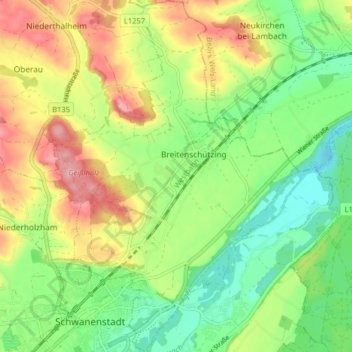
Name: Schlatt topographic map, elevation, terrain.
Location: Schlatt, Bezirk Vöcklabruck, Oberösterreich, 4690, Österreich (48.04993 13.76411 48.10352 13.82267)
Average elevation: 1,319 ft
Minimum elevation: 1,145 ft
Maximum elevation: 1,555 ft
Make a donation
Gear up for your next adventure:
As an Amazon Associate, this site earns from qualifying purchases at no extra cost to you.
Other topographic maps
Click on a map to view its topography, its elevation and its terrain.
Unterthumberg
Österreich > Oberösterreich > Bezirk Vöcklabruck > Neukirchen an der Vöckla
Average elevation: 1,591 ft
Niederpuchheim
Österreich > Oberösterreich > Bezirk Vöcklabruck > Ottnang am Hausruck
Average elevation: 1,955 ft
Aussichtsturm Göblberg
Österreich > Oberösterreich > Bezirk Vöcklabruck > Ampflwang im Hausruckwald
Average elevation: 2,231 ft
Make a donation
Gear up for your next adventure:
As an Amazon Associate, this site earns from qualifying purchases at no extra cost to you.
Ackersberg
Österreich > Oberösterreich > Bezirk Vöcklabruck > Neukirchen an der Vöckla
Average elevation: 1,932 ft
Make a donation
Gear up for your next adventure:
As an Amazon Associate, this site earns from qualifying purchases at no extra cost to you.
Hoblschlag
Österreich > Oberösterreich > Bezirk Vöcklabruck > Frankenburg am Hausruck
Average elevation: 2,152 ft
Rothauptberg
Österreich > Oberösterreich > Bezirk Vöcklabruck > Neukirchen an der Vöckla
Average elevation: 2,139 ft
Innerlohen
Österreich > Oberösterreich > Bezirk Vöcklabruck > Wildenhag im Attergau
Average elevation: 1,923 ft
Make a donation
Gear up for your next adventure:
As an Amazon Associate, this site earns from qualifying purchases at no extra cost to you.
Neubrunn
Österreich > Oberösterreich > Bezirk Vöcklabruck > Seewalchen am Attersee
Average elevation: 1,637 ft
Make a donation
Gear up for your next adventure:
As an Amazon Associate, this site earns from qualifying purchases at no extra cost to you.
Badstuben
Österreich > Oberösterreich > Bezirk Vöcklabruck > Frankenburg am Hausruck
Average elevation: 2,031 ft
Gessenschwandt
Österreich > Oberösterreich > Bezirk Vöcklabruck > Oberwang
Average elevation: 2,362 ft
Make a donation
Gear up for your next adventure:
As an Amazon Associate, this site earns from qualifying purchases at no extra cost to you.
Make a donation
Gear up for your next adventure:
As an Amazon Associate, this site earns from qualifying purchases at no extra cost to you.
Achleithen
Österreich > Oberösterreich > Bezirk Vöcklabruck > Ottnang am Hausruck
Average elevation: 1,762 ft
Redl
Österreich > Oberösterreich > Bezirk Vöcklabruck > Ottnang am Hausruck
Average elevation: 1,854 ft
Steinwand
Österreich > Oberösterreich > Bezirk Vöcklabruck > Weißenkirchen im Attergau > Steinwand
Average elevation: 1,890 ft
Make a donation
Gear up for your next adventure:
As an Amazon Associate, this site earns from qualifying purchases at no extra cost to you.
Rossmoos
Österreich > Oberösterreich > Bezirk Vöcklabruck > Nußdorf am Attersee
Average elevation: 2,762 ft
Make a donation
Gear up for your next adventure:
As an Amazon Associate, this site earns from qualifying purchases at no extra cost to you.