Geolocate

Stand Off topographic map

Click on the map to display elevation.

About this map

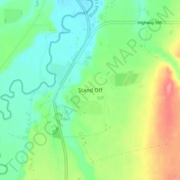
Name: Stand Off topographic map, elevation, terrain.

Location: Stand Off, Cardston County, Alberta, Canada (49.44171 -113.32009 49.48171 -113.28009)

Average elevation: 3,320 ft

Minimum elevation: 3,228 ft

Maximum elevation: 3,491 ft

Gear up for your next adventure:

🥄Camping Utensil Set - Lightweight utensils for outdoor meals
📶Vehicle Signal Boosters - Improve reception in rural areas while driving to trailheads
Backpacking Tents - Weight-optimized shelters for multi-day topographic surveys
🕶️GPS Smartphone Mount - Secure mount for phone navigation
🪑Portable Camp Table - Compact table for campsite meals

As an Amazon Associate, this site earns from qualifying purchases at no extra cost to you.