Geolocate

Lexington topographic map

Click on the map to display elevation.

About this map

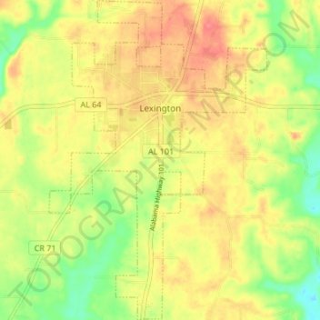
Name: Lexington topographic map, elevation, terrain.

Location: Lexington, Lauderdale County, Alabama, United States (34.93254 -87.39464 34.98786 -87.34857)

Average elevation: 741 ft

Minimum elevation: 623 ft

Maximum elevation: 837 ft

Lauderdale County trails, hiking, mountain biking, running and outdoor activities

Other topographic maps

Click on a map to view its topography, its elevation and its terrain.

Creekwood

United States > Alabama > Lauderdale County > Florence

Average elevation: 591 ft

Killen

United States > Alabama > Lauderdale County

Average elevation: 594 ft

Rogersville

United States > Alabama > Lauderdale County

Average elevation: 646 ft

Gear up for your next adventure:

Backpacking Tent - Lightweight and durable tent for multi‑day hikes
👖Convertible Hiking Pants - Versatile zip-off pants for changing altitudes and temperatures
🩳Quick‑Dry Hiking Shorts - Comfortable and quick‑dry shorts for summer hiking
🚁Photography Drones - Capture stunning aerial views of landforms and topography
🪶Compact Camp Shovel - Folding shovel for campsite tasks

As an Amazon Associate, this site earns from qualifying purchases at no extra cost to you.