Geolocate

Altomonte topographic map

Click on the map to display elevation.

About this map

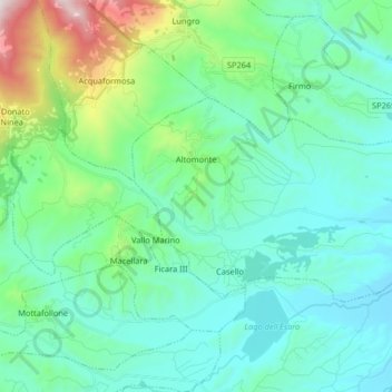
Name: Altomonte topographic map, elevation, terrain.

Location: Altomonte, Cosenza, Calabria, 87042, Italy (39.65233 16.10034 39.71985 16.26317)

Average elevation: 1,161 ft

Minimum elevation: 279 ft

Maximum elevation: 4,902 ft

Other topographic maps

Click on a map to view its topography, its elevation and its terrain.

Sila National Park

Italy > Calabria > Cosenza

Average elevation: 2,933 ft

Quattromiglia

Italy > Calabria > Cosenza > Rende

Average elevation: 633 ft

Lago Tarsia

Italy > Calabria > Cosenza > Tarsia

Average elevation: 453 ft

Corigliano Calabro

Italy > Calabria > Cosenza

Average elevation: 758 ft

Trenta

Italy > Calabria > Cosenza

Trenta is a town high in the Crati river Valley. The town's ancient name, Triginta, derives from the Latin number triginta or thirty. Trenta was founded by Cosentine refugees in the 10th century AD, in the era of Saracen occupations of the nearby capital, Magli, which eventually became one of the…

Average elevation: 1,837 ft

Lauropoli

Italy > Calabria > Cosenza > Cassano all'Ionio > Lauropoli

Average elevation: 689 ft

Sibari

Italy > Calabria > Cosenza > Cassano all'Ionio > Sibari

Average elevation: 23 ft

Pastina

Italy > Calabria > Cosenza > Santa Maria del Cedro

Average elevation: 400 ft

Gear up for your next adventure:

📻Weather Alert Radios - Stay informed of storm risks while off-the-grid
📷Action Camera - Capture your outdoor adventures in HD
🎒Waterproof Dry Bags - Keep your electronics and maps dry inside your pack
🗃️Trail First Aid Kit - Essential kit for outdoor injuries and emergencies
🧷Carabiner Set - Durable clips for gear attachment

As an Amazon Associate, this site earns from qualifying purchases at no extra cost to you.