Geolocate

Trenta topographic map

Click on the map to display elevation.

Trenta

Trenta is a town high in the Crati river Valley. The town's ancient name, Triginta, derives from the Latin number triginta or thirty. Trenta was founded by Cosentine refugees in the 10th century AD, in the era of Saracen occupations of the nearby capital, Magli, which eventually became one of the administrative divisions that comprise the town of Trenta. The other divisions include Schiavonea, Feruci, Cribari, Catena, and Morelli. The town itself is made up of 4.65 square kilometers (1.80 sq mi), and sits at an altitude of over 600 meters above sea level.

Wikipedia (CC-BY-SA 3.0)

About this map

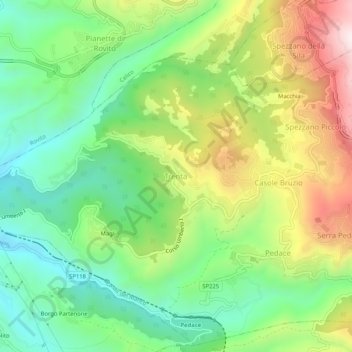
Name: Trenta topographic map, elevation, terrain.

Location: Trenta, Casali del Manco, Cosenza, Calabria, 87059, Italy (39.26509 16.30140 39.30509 16.34140)

Average elevation: 1,837 ft

Minimum elevation: 1,033 ft

Maximum elevation: 3,127 ft

Other topographic maps

Click on a map to view its topography, its elevation and its terrain.

Sila National Park

Italy > Calabria > Cosenza

Average elevation: 2,933 ft

Santa Domenica Talao

Italy > Calabria > Cosenza

Vegetation includes Mediterranean scrub and olive groves at lower elevations, chestnut and oak woods on the hills, and mixed beech–silver fir stands at higher altitudes. Protected fauna in the Pollino National Park include roe deer, the Apennine wolf, golden eagle and several raptors.

Average elevation: 1,056 ft

Altomonte

Italy > Calabria > Cosenza

Average elevation: 1,161 ft

Castrolibero

Italy > Calabria > Cosenza

Average elevation: 1,207 ft

San Giovanni in Fiore

Italy > Calabria > Cosenza

Average elevation: 3,468 ft

Rende

Italy > Calabria > Cosenza

Average elevation: 1,280 ft

Colosimi

Italy > Calabria > Cosenza

Average elevation: 3,143 ft

Scalea

Italy > Calabria > Cosenza

Average elevation: 167 ft

Lago

Italy > Calabria > Cosenza

Lago is located in the mountainous interior of the Cosenza Province, near the slopes of Monte Cocuzzo. Despite being sited in mountainous territory, the higher elevations of the city offer views of the nearby coastline, including Stromboli. It regularly snows in Lago in the winter.

Average elevation: 2,493 ft

Rose

Italy > Calabria > Cosenza

Average elevation: 1,572 ft

Bisignano

Italy > Calabria > Cosenza

Average elevation: 840 ft

Mormanno

Italy > Calabria > Cosenza

Average elevation: 2,743 ft

San Marco Argentano

Italy > Calabria > Cosenza

Average elevation: 991 ft

Cassano all'Ionio

Italy > Calabria > Cosenza

Average elevation: 509 ft

Castrolibero

Italy > Calabria > Cosenza

Average elevation: 1,207 ft

Lago Tarsia

Italy > Calabria > Cosenza > Tarsia

Average elevation: 453 ft

Terranova da Sibari

Italy > Calabria > Cosenza

Average elevation: 495 ft

Cassano all'Ionio

Italy > Calabria > Cosenza

Average elevation: 755 ft

Tarsia

Italy > Calabria > Cosenza

Average elevation: 594 ft

Spezzano Albanese

Italy > Calabria > Cosenza

Average elevation: 472 ft

Mendicino

Italy > Calabria > Cosenza

Average elevation: 2,297 ft

Zumpano

Italy > Calabria > Cosenza

Average elevation: 1,401 ft

Rose

Italy > Calabria > Cosenza

Average elevation: 1,572 ft

Pietrapaola

Italy > Calabria > Cosenza > Pietrapaola

Average elevation: 860 ft

Gear up for your next adventure:

🗻Climbing Gear Basics - Essential gear for beginner climbers
☀️Outdoor Sunscreen - High protection sunscreen for outdoor activities
🧭Hiking Compass - Precision compass for reliable navigation in the wilderness
🎒Hydration Pack - Hands‑free water reservoir for long hikes
🗺️NatGeo Topo Maps - High-quality waterproof printed topographic maps of US Parks

As an Amazon Associate, this site earns from qualifying purchases at no extra cost to you.