Geolocate

Pine Grove topographic map

Click on the map to display elevation.

About this map

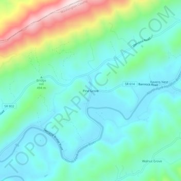
Name: Pine Grove topographic map, elevation, terrain.

Location: Pine Grove, Washington County, Virginia, 24270, United States (36.70260 -82.28792 36.74260 -82.24792)

Average elevation: 1,745 ft

Minimum elevation: 1,342 ft

Maximum elevation: 3,025 ft

Washington County trails, hiking, mountain biking, running and outdoor activities

Other topographic maps

Click on a map to view its topography, its elevation and its terrain.

Glade Spring

United States > Virginia > Washington County

The elevation is 2,087 ft above sea level.

Average elevation: 2,159 ft

Gear up for your next adventure:

📷Action Cameras - Rugged cameras to document your journeys across rugged terrain
🥇GPS Hiking Watch - Multi‑sport GPS watch with navigation and trail tracking
🔌USB Car Charger - Car charger for on‑the‑go power needs
🧯Emergency Survival Kit - All‑in‑one survival essentials for the backcountry
🚁Photography Drones - Capture stunning aerial views of landforms and topography

As an Amazon Associate, this site earns from qualifying purchases at no extra cost to you.