Geolocate

Glade Spring topographic map

Click on the map to display elevation.

Glade Spring

The elevation is 2,087 ft above sea level.

Wikipedia (CC-BY-SA 3.0)

About this map

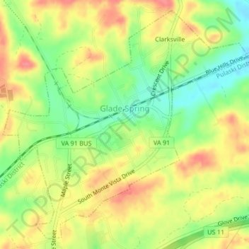
Name: Glade Spring topographic map, elevation, terrain.

Location: Glade Spring, Washington County, Virginia, United States (36.77707 -81.78774 36.80182 -81.75442)

Average elevation: 2,159 ft

Minimum elevation: 2,034 ft

Maximum elevation: 2,270 ft

Washington County trails, hiking, mountain biking, running and outdoor activities

Other topographic maps

Click on a map to view its topography, its elevation and its terrain.

Pine Grove

United States > Virginia > Washington County

Average elevation: 1,745 ft

Meadowview

United States > Virginia > Washington County

Average elevation: 2,159 ft

Booker

United States > Virginia > Washington County

Average elevation: 1,969 ft

Konnarock

United States > Virginia > Washington County > Konnarock

Average elevation: 3,297 ft

Brumley Gap

United States > Virginia > Washington County > Brumley Gap

Average elevation: 1,975 ft

Gear up for your next adventure:

🚁Photography Drones - Capture stunning aerial views of landforms and topography
🛠️Backpacking Tool Kit - Essential toolkit for outdoor repairs
🌡️Portable Weather Meter - Track weather conditions on the trail
📦Dry Bags Set - Waterproof storage for electronics and clothes
🛡️Bear Spray Outdoor - Protection in bear country hikes

As an Amazon Associate, this site earns from qualifying purchases at no extra cost to you.