
Make a donation
Gear up for your next adventure:
As an Amazon Associate, this site earns from qualifying purchases at no extra cost to you.
Muncho Lake topographic map
Click on the map to display elevation.
Make a donation
Gear up for your next adventure:
As an Amazon Associate, this site earns from qualifying purchases at no extra cost to you.
Muncho Lake
The lake is part of the Muncho Lake Provincial Park and located at kilometre 681 (mile 423) of the Alaska Highway. The lake is about 12 km (7.5 mi) long and its width varies. It reaches a maximum depth of 110 m (360 ft). The surrounding peaks (the Terminal Range of the Muskwa Ranges to the west and the Sentinel Range to the east) reach altitudes of more than 2,000 m (6,600 ft), while the lake lies at an elevation of 820 m (2,690 ft). It is formed along the Trout River, a tributary of the Liard River.
Make a donation
Gear up for your next adventure:
As an Amazon Associate, this site earns from qualifying purchases at no extra cost to you.
About this map
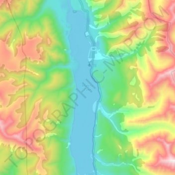
Name: Muncho Lake topographic map, elevation, terrain.
Average elevation: 4,337 ft
Minimum elevation: 2,680 ft
Maximum elevation: 7,333 ft
Make a donation
Gear up for your next adventure:
As an Amazon Associate, this site earns from qualifying purchases at no extra cost to you.
Other topographic maps
Click on a map to view its topography, its elevation and its terrain.
Fort Nelson
Canada > British Columbia > Northern Rockies Regional Municipality
Average elevation: 1,329 ft
Tetsa River
Canada > British Columbia > Northern Rockies Regional Municipality
Average elevation: 5,282 ft
Rocky Mountains
Canada > British Columbia > Northern Rockies Regional Municipality
Average elevation: 4,360 ft
Nelson Forks
Canada > British Columbia > Northern Rockies Regional Municipality
Average elevation: 974 ft
Make a donation
Gear up for your next adventure:
As an Amazon Associate, this site earns from qualifying purchases at no extra cost to you.
Toad River
Canada > British Columbia > Northern Rockies Regional Municipality
Average elevation: 2,726 ft
Magnum Mine
Canada > British Columbia > Northern Rockies Regional Municipality
Average elevation: 3,596 ft
Fort Nelson
Canada > British Columbia > Northern Rockies Regional Municipality
Average elevation: 1,325 ft
Fort Nelson
Canada > British Columbia > Northern Rockies Regional Municipality
Average elevation: 1,325 ft
Make a donation
Gear up for your next adventure:
As an Amazon Associate, this site earns from qualifying purchases at no extra cost to you.