
Perton topographic map
Click on the map to display elevation.
About this map
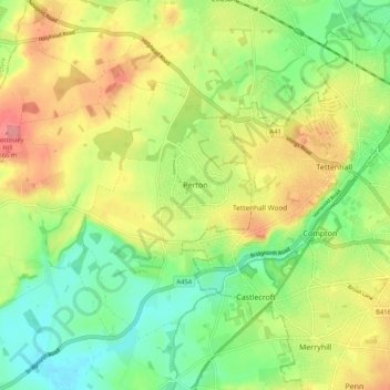
Name: Perton topographic map, elevation, terrain.
Average elevation: 404 ft
Minimum elevation: 272 ft
Maximum elevation: 568 ft
Other topographic maps
Click on a map to view its topography, its elevation and its terrain.
Levedale
United Kingdom > England > Staffordshire > South Staffordshire > Penkridge
Average elevation: 322 ft
Six Ashes
United Kingdom > England > Staffordshire > South Staffordshire > Bobbington
Average elevation: 410 ft
Weston Park
United Kingdom > England > Staffordshire > South Staffordshire > Weston under Lizard
Average elevation: 371 ft
Himley
United Kingdom > England > Staffordshire > South Staffordshire > Himley
Average elevation: 315 ft
Bednall
United Kingdom > England > Staffordshire > South Staffordshire > Bednall
Average elevation: 387 ft
Halfpenny Green
United Kingdom > England > Staffordshire > South Staffordshire
Average elevation: 299 ft
Acton Trussell
United Kingdom > England > Staffordshire > South Staffordshire
Average elevation: 305 ft
Calf Heath
United Kingdom > England > Staffordshire > South Staffordshire > Hatherton Junction
Average elevation: 371 ft
Mottey Meadows NNR
United Kingdom > England > Staffordshire > South Staffordshire > Wheaton Aston
Average elevation: 361 ft
Whiston
United Kingdom > England > Staffordshire > South Staffordshire > Penkridge
Average elevation: 312 ft
Lutley
United Kingdom > England > Staffordshire > South Staffordshire > Enville
Average elevation: 328 ft
Weston under Lizard
United Kingdom > England > Staffordshire > South Staffordshire
Average elevation: 364 ft
Wheaton Aston
United Kingdom > England > Staffordshire > South Staffordshire
Average elevation: 348 ft
Baggeridge Country Park
United Kingdom > England > Staffordshire > South Staffordshire
Average elevation: 479 ft
Kinver Edge
United Kingdom > England > Staffordshire > South Staffordshire > Kinver
Average elevation: 312 ft
Cannock Lake
United Kingdom > England > Staffordshire > South Staffordshire > Huntington
Average elevation: 489 ft
Hatherton Junction
United Kingdom > England > Staffordshire > South Staffordshire
Average elevation: 367 ft
Gospelash
United Kingdom > England > Staffordshire > South Staffordshire > Bobbington
Average elevation: 299 ft
Wheaton Aston
United Kingdom > England > Staffordshire > South Staffordshire
Average elevation: 348 ft
Kinver Edge
United Kingdom > England > Staffordshire > South Staffordshire > Kinver
Average elevation: 312 ft