
Make a donation
Gear up for your next adventure:
As an Amazon Associate, this site earns from qualifying purchases at no extra cost to you.
Weston under Lizard topographic map
Click on the map to display elevation.
Make a donation
Gear up for your next adventure:
As an Amazon Associate, this site earns from qualifying purchases at no extra cost to you.
About this map
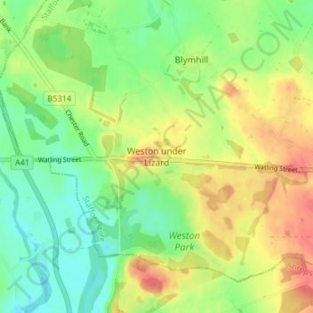
Name: Weston under Lizard topographic map, elevation, terrain.
Average elevation: 364 ft
Minimum elevation: 279 ft
Maximum elevation: 466 ft
Make a donation
Gear up for your next adventure:
As an Amazon Associate, this site earns from qualifying purchases at no extra cost to you.
Other topographic maps
Click on a map to view its topography, its elevation and its terrain.
Make a donation
Gear up for your next adventure:
As an Amazon Associate, this site earns from qualifying purchases at no extra cost to you.
Weston Park
United Kingdom > England > Staffordshire > South Staffordshire > Weston under Lizard
Average elevation: 371 ft
Himley
United Kingdom > England > Staffordshire > South Staffordshire > Himley
Average elevation: 387 ft
Make a donation
Gear up for your next adventure:
As an Amazon Associate, this site earns from qualifying purchases at no extra cost to you.
Highgate Common
United Kingdom > England > Staffordshire > South Staffordshire > Enville
Average elevation: 302 ft
Mottey Meadows NNR
United Kingdom > England > Staffordshire > South Staffordshire > Wheaton Aston
Average elevation: 361 ft
Make a donation
Gear up for your next adventure:
As an Amazon Associate, this site earns from qualifying purchases at no extra cost to you.
Shareshill
United Kingdom > England > Staffordshire > South Staffordshire > Shareshill
Average elevation: 404 ft
Baggeridge Country Park
United Kingdom > England > Staffordshire > South Staffordshire
Average elevation: 479 ft
Make a donation
Gear up for your next adventure:
As an Amazon Associate, this site earns from qualifying purchases at no extra cost to you.
Wombourne
United Kingdom > England > Staffordshire > South Staffordshire > Wombourne
Average elevation: 367 ft
Cannock Lake
United Kingdom > England > Staffordshire > South Staffordshire > Huntington
Average elevation: 489 ft
Make a donation
Gear up for your next adventure:
As an Amazon Associate, this site earns from qualifying purchases at no extra cost to you.