Geolocate

Monte Rinaldo topographic map

Click on the map to display elevation.

About this map

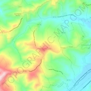
Name: Monte Rinaldo topographic map, elevation, terrain.

Location: Monte Rinaldo, Fermo, Marche, 63852, Italy (43.00819 13.55898 43.05145 13.60120)

Average elevation: 1,053 ft

Minimum elevation: 630 ft

Maximum elevation: 1,791 ft

Other topographic maps

Click on a map to view its topography, its elevation and its terrain.

Coriconi

Italy > Marche > Fermo > Amandola

Average elevation: 1,657 ft

Gear up for your next adventure:

🔥Camping Stove - Portable stove for camping and backcountry cooking
🌡️Portable Weather Meter - Track weather conditions on the trail
🌄Hiking Binoculars - Compact binoculars for scenic views and trail spotting
🦟Ultrasonic Repellers - Create a bug-free zone at your camp or rest stop
🧣Merino Neck Gaiters - Multi-functional headwear for wind and sun protection

As an Amazon Associate, this site earns from qualifying purchases at no extra cost to you.