Geolocate

Bertram topographic map

Click on the map to display elevation.

About this map

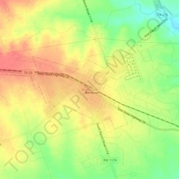
Name: Bertram topographic map, elevation, terrain.

Location: Bertram, Burnet County, Texas, 78605, United States (30.72376 -98.07543 30.76376 -98.03543)

Average elevation: 1,220 ft

Minimum elevation: 1,106 ft

Maximum elevation: 1,306 ft

Burnet County trails, hiking, mountain biking, running and outdoor activities

Gear up for your next adventure:

🛠️Outdoor Gear Repair Kit - Essential tools to fix gear on the trail
🧭Hiking Compass - Precision compass for reliable navigation in the wilderness
🌡️Handheld Weather Meters - Measure wind, temp, and pressure for safe mountain travel
🗺️Topographic Maps - Detailed topo maps for hiking, exploring and outdoor navigation
🛠️Backpacking Tool Kit - Essential toolkit for outdoor repairs

As an Amazon Associate, this site earns from qualifying purchases at no extra cost to you.