
Ibadan North topographic map
Interactive map
Click on the map to display elevation.
About this map
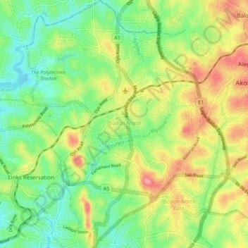
Name: Ibadan North topographic map, elevation, terrain.
Location: Ibadan North, Oyo State, Nigeria (7.37961 3.87616 7.46186 3.93652)
Average elevation: 705 ft
Minimum elevation: 564 ft
Maximum elevation: 909 ft
Other topographic maps
Click on a map to view its topography, its elevation and its terrain.
river Sowori
Nigeria > Oyo State > Ibarapa East > Jankata
river Sowori, Jankata, Ibarapa East, Oyo State, Nigeria
Average elevation: 482 ft
Ibadan
Nigeria > Oyo State > Ibadan South West
Ibadan, Ibadan South West, Oyo State, 234102, Nigeria
Average elevation: 627 ft