Geolocate

Junín topographic map

Click on the map to display elevation.

About this map

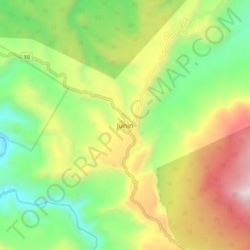
Name: Junín topographic map, elevation, terrain.

Location: Junín, Barbacoas, Telembí, Nariño, RAP Pacífico, Colombia (1.29312 -78.15803 1.37312 -78.07803)

Average elevation: 3,169 ft

Minimum elevation: 1,496 ft

Maximum elevation: 5,604 ft

Other topographic maps

Click on a map to view its topography, its elevation and its terrain.

Santacruz

Colombia > Nariño

Average elevation: 6,873 ft

Pasto

Colombia > Nariño > Pasto

Most of the city lies between 2,520 metres (8,270 ft) and 2,700 metres (8,900 ft) elevation above sea level, while some settlement exceeds 3,000 metres (9,800 ft) on the flanks of the Galeras Volcano, which stands at 4,276 metres (14,029 ft).

Average elevation: 8,780 ft

Cumbal

Colombia > Nariño

Average elevation: 10,144 ft

Samaniego

Colombia > Nariño

Average elevation: 6,027 ft

Aldana

Colombia > Nariño

Average elevation: 10,115 ft

Tumaco

Colombia > Nariño

Average elevation: 164 ft

Pasto

Colombia > Nariño > Pasto

Most of the city lies between 2,520 metres (8,270 ft) and 2,700 metres (8,900 ft) elevation above sea level, while some settlement exceeds 3,000 metres (9,800 ft) on the flanks of the Galeras Volcano, which stands at 4,276 metres (14,029 ft).

Average elevation: 8,780 ft

Samaniego

Colombia > Nariño

Average elevation: 6,027 ft

Gualmatán

Colombia > Nariño

Average elevation: 10,023 ft

Santacruz

Colombia > Nariño

Average elevation: 6,873 ft

Santacruz

Colombia > Nariño > Santacruz

Average elevation: 6,873 ft

La Sabana

Colombia > Nariño

Average elevation: 8,540 ft

Potosí

Colombia > Nariño > Potosí

Potosí features a rare climate for a city of its size, due to its extreme elevation at over 4000m. Semi-arid and with average temperatures in its warmest month sitting right on the 10 °C threshold, the city's climate straddles that of the subtropical highland climate (Cwc, according to the Köppen climate…

Average elevation: 8,901 ft

Pasto

Colombia > Nariño > Pasto > Pasto

Most of the city lies between 2,520 metres (8,270 ft) and 2,700 metres (8,900 ft) elevation above sea level, while some settlement exceeds 3,000 metres (9,800 ft) on the flanks of the Galeras Volcano, which stands at 4,276 metres (14,029 ft).

Average elevation: 8,753 ft

Pasto

Colombia > Nariño > Pasto

Most of the city lies between 2,520 metres (8,270 ft) and 2,700 metres (8,900 ft) elevation above sea level, while some settlement exceeds 3,000 metres (9,800 ft) on the flanks of the Galeras Volcano, which stands at 4,276 metres (14,029 ft).

Average elevation: 8,780 ft

Mallama

Colombia > Nariño

Average elevation: 6,919 ft

Guambuyaco

Colombia > Nariño

Average elevation: 3,350 ft

El Peñol

Colombia > Nariño

Average elevation: 3,773 ft

Gear up for your next adventure:

🥤Water Filter Bottle - All‑in‑one filter bottle for safe hydration
🧭Outdoor Navigation Book - Learn advanced navigation skills
🔦Compact Flashlight - Reliable flashlight for emergencies
Solar GPS Watches - Advanced multisport watches with built-in topographic maps
📶Satellite Messenger - Communication device off‑grid

As an Amazon Associate, this site earns from qualifying purchases at no extra cost to you.