
Axum topographic map
Click on the map to display elevation.
Axum
Axum is located in the Central Zone of the Tigray Region, near the base of the Adwa mountains. It has an elevation of 2,131 metres (6,991 feet) and is surrounded by La'ilay Maychew, a separately administered woreda of the Tigray region.
About this map
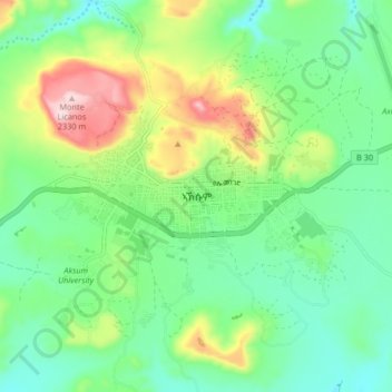
Name: Axum topographic map, elevation, terrain.
Location: Axum, Central Tigray, Tigray, Ethiopia (14.08210 38.69217 14.16210 38.77217)
Average elevation: 6,985 ft
Minimum elevation: 6,650 ft
Maximum elevation: 7,720 ft
Other topographic maps
Click on a map to view its topography, its elevation and its terrain.
Mek'elē
Mekelle (Tigrinya: መቐለ), or Mekele, is a special zone and capital of the Tigray Region of Ethiopia. Mekelle was formerly the capital of Enderta awraja in Tigray. It is located around 780 kilometres (480 mi) north of the Ethiopian capital Addis Ababa, with an elevation of 2,254 metres (7,395 ft) above sea…
Average elevation: 6,857 ft
Alamata
Alamata (Tigrinya: ኣላማጣ ) is a town in the Tigray Region of Ethiopia. Located in the Debubawi (Southern) zone of Tigray it has a latitude and longitude of 12°25′N 39°33′E / 12.417°N 39.550°E / 12.417; 39.550 and an elevation of 1,520 metres (4,990 ft) above sea level and is located…
Average elevation: 5,164 ft
Mek'elē
Mekelle (Tigrinya: መቐለ), or Mekele, is a special zone and capital of the Tigray Region of Ethiopia. Mekelle was formerly the capital of Enderta awraja in Tigray. It is located around 780 kilometres (480 mi) north of the Ethiopian capital Addis Ababa, with an elevation of 2,254 metres (7,395 ft) above sea…
Average elevation: 6,857 ft
Mek'elē
Mekelle (Tigrinya: መቐለ), or Mek'ele, is a special zone and capital of the Tigray Region of Ethiopia. Mekelle was formerly the capital of Enderta awraja in Tigray. It is located around 780 kilometres (480 mi) north of the Ethiopian capital Addis Ababa, with an elevation of 2,254 metres (7,395 ft) above…
Average elevation: 6,857 ft