
Make a donation
Gear up for your next adventure:
As an Amazon Associate, this site earns from qualifying purchases at no extra cost to you.
Tijuana topographic map
Click on the map to display elevation.
Make a donation
Gear up for your next adventure:
As an Amazon Associate, this site earns from qualifying purchases at no extra cost to you.
About this map
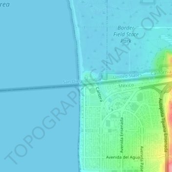
Name: Tijuana topographic map, elevation, terrain.
Average elevation: 36 ft
Minimum elevation: -3 ft
Maximum elevation: 322 ft
Make a donation
Gear up for your next adventure:
As an Amazon Associate, this site earns from qualifying purchases at no extra cost to you.
Other topographic maps
Click on a map to view its topography, its elevation and its terrain.
Baja Malibu
México > Baja California > Municipio de Tijuana > San Antonio del Mar
Average elevation: 141 ft
Parque II Hacienda los Laureles
México > Baja California > Municipio de Tijuana > San Luis
Average elevation: 846 ft
El Florido
México > Baja California > Municipio de Tijuana > Ejido Maclovio Rojas
Average elevation: 758 ft
Make a donation
Gear up for your next adventure:
As an Amazon Associate, this site earns from qualifying purchases at no extra cost to you.
San Marino
México > Baja California > Municipio de Tijuana > San Antonio del Mar
Average elevation: 141 ft
Make a donation
Gear up for your next adventure:
As an Amazon Associate, this site earns from qualifying purchases at no extra cost to you.
Parque Lomas de la Presa
México > Baja California > Municipio de Tijuana > Tijuana
Average elevation: 554 ft