Geolocate

Milford topographic map

Click on the map to display elevation.

About this map

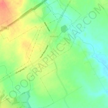
Name: Milford topographic map, elevation, terrain.

Location: Milford, Ellis County, Texas, 76670, United States (32.09810 -96.96886 32.13798 -96.93340)

Average elevation: 614 ft

Minimum elevation: 541 ft

Maximum elevation: 709 ft

Ellis County trails, hiking, mountain biking, running and outdoor activities

Other topographic maps

Click on a map to view its topography, its elevation and its terrain.

Boz

United States > Texas > Ellis County

Average elevation: 636 ft

Bristol

United States > Texas > Ellis County > Bristol

Average elevation: 456 ft

Ferris

United States > Texas > Ellis County > Ferris > Ferris

Average elevation: 446 ft

Five Points

United States > Texas > Ellis County

Average elevation: 584 ft

Gear up for your next adventure:

🧭GPS Watch Accessories - Bands and chargers for GPS watches
🦶Carbon Trekking Poles - Reduce knee impact on steep descents with ultra-light poles
👓Polarized Sunglasses - Outdoor sunglasses for glare reduction
🔭Compact Binoculars - HD vision for scouting terrain and identifying distant landmarks
🔭Telescopic Hiking Pole - Adjustable pole for hiking stability

As an Amazon Associate, this site earns from qualifying purchases at no extra cost to you.