Geolocate

Sandy topographic map

Click on the map to display elevation.

About this map

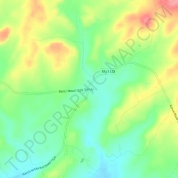
Name: Sandy topographic map, elevation, terrain.

Location: Sandy, Blanco County, Texas, United States (30.34075 -98.48947 30.38075 -98.44947)

Average elevation: 1,362 ft

Minimum elevation: 1,230 ft

Maximum elevation: 1,549 ft

Blanco County trails, hiking, mountain biking, running and outdoor activities

Other topographic maps

Click on a map to view its topography, its elevation and its terrain.

Round Mountain

United States > Texas > Blanco County

Average elevation: 1,312 ft

Blanco

United States > Texas > Blanco County

Average elevation: 1,398 ft

Blanco State Park

United States > Texas > Blanco County > Blanco

Average elevation: 1,368 ft

Pedernales Falls Road

United States > Texas > Blanco County

Average elevation: 1,017 ft

Pedernales River

United States > Texas > Blanco County

Average elevation: 1,237 ft

Gear up for your next adventure:

🎒Trekking Poles - Sturdy poles for balance and stability on rough terrain
🪵Folding Camp Saw - Compact saw for wood and campsite work
🕶️GPS Smartphone Mount - Secure mount for phone navigation
🪶Multi‑Purpose Knife - Useful blade for camp and trail
🧭Compass with Lanyard - Easy‑carry compass for navigation

As an Amazon Associate, this site earns from qualifying purchases at no extra cost to you.