Geolocate

Blanco topographic map

Click on the map to display elevation.

About this map

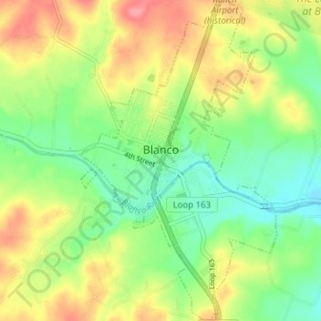
Name: Blanco topographic map, elevation, terrain.

Location: Blanco, Blanco County, Texas, 78606, United States (30.07163 -98.43775 30.12603 -98.39925)

Average elevation: 1,398 ft

Minimum elevation: 1,276 ft

Maximum elevation: 1,552 ft

Blanco County trails, hiking, mountain biking, running and outdoor activities

Other topographic maps

Click on a map to view its topography, its elevation and its terrain.

Hye

United States > Texas > Blanco County

Average elevation: 1,460 ft

Sandy

United States > Texas > Blanco County

Average elevation: 1,362 ft

Rocky Creek

United States > Texas > Blanco County

Average elevation: 1,404 ft

Round Mountain

United States > Texas > Blanco County

Average elevation: 1,312 ft

Tosca

United States > Texas > Blanco County

Average elevation: 1,680 ft

Blanco State Park

United States > Texas > Blanco County > Blanco

Average elevation: 1,368 ft

Pedernales Falls Road

United States > Texas > Blanco County

Average elevation: 1,017 ft

Pedernales River

United States > Texas > Blanco County

Average elevation: 1,237 ft

Payton

United States > Texas > Blanco County

Average elevation: 1,385 ft

Gear up for your next adventure:

🧤Hiking Gloves - Protective gloves for rugged trails
🦶Carbon Trekking Poles - Reduce knee impact on steep descents with ultra-light poles
🛰️Satellite Messengers - Emergency SOS and two-way messaging for off-grid adventures
🔥Camping Stove - Portable stove for camping and backcountry cooking
🌧️Backpack Rain Cover - Keep gear dry in wet weather

As an Amazon Associate, this site earns from qualifying purchases at no extra cost to you.