
Make a donation
Gear up for your next adventure:
As an Amazon Associate, this site earns from qualifying purchases at no extra cost to you.
Meadows topographic map
Click on the map to display elevation.
Make a donation
Gear up for your next adventure:
As an Amazon Associate, this site earns from qualifying purchases at no extra cost to you.
About this map
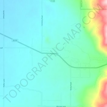
Name: Meadows topographic map, elevation, terrain.
Location: Meadows, Adams County, Idaho, 83664, United States (44.94100 -116.26374 44.98100 -116.22374)
Average elevation: 4,026 ft
Minimum elevation: 3,862 ft
Maximum elevation: 4,728 ft
Adams County trails, hiking, mountain biking, running and outdoor activities
Make a donation
Gear up for your next adventure:
As an Amazon Associate, this site earns from qualifying purchases at no extra cost to you.
Other topographic maps
Click on a map to view its topography, its elevation and its terrain.
New Meadows
United States > Idaho > Adams County
New Meadows is located at 44°58′13″N 116°17′7″W / 44.97028°N 116.28528°W / 44.97028; -116.28528 (44.970405, -116.285283), at an elevation of 3,868 feet (1,179 m) above sea level.
Average elevation: 3,885 ft