Geolocate

Diamond topographic map

Click on the map to display elevation.

About this map

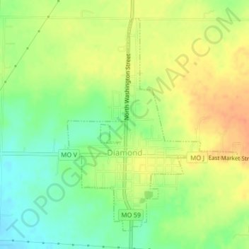
Name: Diamond topographic map, elevation, terrain.

Location: Diamond, Newton County, Missouri, United States (36.98684 -94.32388 37.00984 -94.30078)

Average elevation: 1,161 ft

Minimum elevation: 1,089 ft

Maximum elevation: 1,224 ft

Newton County trails, hiking, mountain biking, running and outdoor activities

Other topographic maps

Click on a map to view its topography, its elevation and its terrain.

Hornet

United States > Missouri > Newton County

Average elevation: 1,096 ft

Gateway Drive

United States > Missouri > Newton County > Joplin

Average elevation: 1,047 ft

Westview

United States > Missouri > Newton County

Average elevation: 1,119 ft

Ritchey

United States > Missouri > Newton County > Ritchey

Average elevation: 1,132 ft

Big Spring Park

United States > Missouri > Newton County > Neosho

Average elevation: 1,093 ft

Gear up for your next adventure:

🪶LED Camping Lantern - Bright lantern for camp lighting
🪄Magnetic Compass - Accurate compass for navigation
🧤Tactile Hiking Gloves - Keep hands warm while operating GPS and smartphone screens
💧Water Filtration Bottles - Safely drink from streams and lakes while exploring
🧭Outdoor Navigation Book - Learn advanced navigation skills

As an Amazon Associate, this site earns from qualifying purchases at no extra cost to you.