
Thank you for supporting this site ❤️
Make a donation
Make a donation
Gear up for your next adventure:
As an Amazon Associate, this site earns from qualifying purchases at no extra cost to you.
Dolgoprudny topographic map
Click on the map to display elevation.
Thank you for supporting this site ❤️
Make a donation
Make a donation
Gear up for your next adventure:
As an Amazon Associate, this site earns from qualifying purchases at no extra cost to you.
About this map
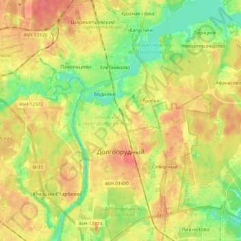
Name: Dolgoprudny topographic map, elevation, terrain.
Location: Dolgoprudny, Moscow Oblast, Central Federal District, Russia (55.89730 37.45482 55.99604 37.53632)
Average elevation: 584 ft
Minimum elevation: 499 ft
Maximum elevation: 659 ft
Thank you for supporting this site ❤️
Make a donation
Make a donation
Gear up for your next adventure:
As an Amazon Associate, this site earns from qualifying purchases at no extra cost to you.