
Make a donation
Gear up for your next adventure:
As an Amazon Associate, this site earns from qualifying purchases at no extra cost to you.
Lake Texoma topographic map
Click on the map to display elevation.
Make a donation
Gear up for your next adventure:
As an Amazon Associate, this site earns from qualifying purchases at no extra cost to you.
Lake Texoma
Normal elevation of the conservation pool varies from 615 to 619 ft (187 to 189 m) National Geodetic Vertical Datum (NGVD) depending on the time of year. The flood control pool extends to elevation 645 ft (197 m) NGVD. The lake has crested the dam's spillway at a height of 640 ft (200 m) five times: once in 1957, again in 1990, 2007, May 24, 2015, and most recently on June 18, 2015. (USACE 2003a) The lake's previously highest elevation was recorded on May 6, 1990, at 644.76 feet. This record was broken on May 29, 2015, and the lake crested on June 1, 2015, at a new record elevation of 645.72 feet. The top of Denison Dam is at 670 feet.
Make a donation
Gear up for your next adventure:
As an Amazon Associate, this site earns from qualifying purchases at no extra cost to you.
About this map
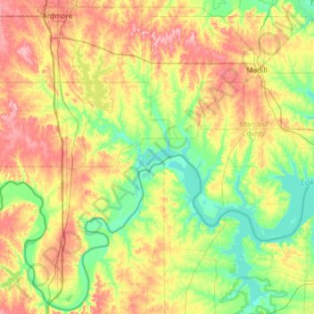
Name: Lake Texoma topographic map, elevation, terrain.
Location: Lake Texoma, Marshall County, Oklahoma, United States (33.71228 -97.06889 34.16391 -96.51384)
Average elevation: 699 ft
Minimum elevation: 486 ft
Maximum elevation: 1,010 ft
Marshall County trails, hiking, mountain biking, running and outdoor activities
Make a donation
Gear up for your next adventure:
As an Amazon Associate, this site earns from qualifying purchases at no extra cost to you.
Other topographic maps
Click on a map to view its topography, its elevation and its terrain.