
Make a donation
Gear up for your next adventure:
As an Amazon Associate, this site earns from qualifying purchases at no extra cost to you.
Antioch topographic map
Click on the map to display elevation.
Make a donation
Gear up for your next adventure:
As an Amazon Associate, this site earns from qualifying purchases at no extra cost to you.
About this map
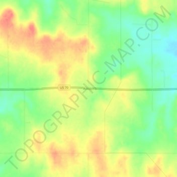
Name: Antioch topographic map, elevation, terrain.
Location: Antioch, Marshall County, Oklahoma, United States (34.08010 -96.84834 34.12010 -96.80834)
Average elevation: 883 ft
Minimum elevation: 791 ft
Maximum elevation: 971 ft
Marshall County trails, hiking, mountain biking, running and outdoor activities
Make a donation
Gear up for your next adventure:
As an Amazon Associate, this site earns from qualifying purchases at no extra cost to you.
Other topographic maps
Click on a map to view its topography, its elevation and its terrain.
Lake Texoma
United States > Oklahoma > Marshall County
Normal elevation of the conservation pool varies from 615 to 619 ft (187 to 189 m) National Geodetic Vertical Datum (NGVD) depending on the time of year. The flood control pool extends to elevation 645 ft (197 m) NGVD. The lake has crested the dam's spillway at a height of 640 ft (200 m) five times: once in…
Average elevation: 699 ft