Geolocate

Zorn topographic map

Click on the map to display elevation.

About this map

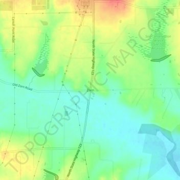
Name: Zorn topographic map, elevation, terrain.

Location: Zorn, Guadalupe County, Texas, United States (29.73300 -97.96806 29.77300 -97.92806)

Average elevation: 554 ft

Minimum elevation: 482 ft

Maximum elevation: 656 ft

Guadalupe County trails, hiking, mountain biking, running and outdoor activities

Other topographic maps

Click on a map to view its topography, its elevation and its terrain.

Santa Clara

United States > Texas > Guadalupe County

Average elevation: 719 ft

New Berlin

United States > Texas > Guadalupe County

Average elevation: 558 ft

Marion

United States > Texas > Guadalupe County

Average elevation: 640 ft

Kingsbury

United States > Texas > Guadalupe County > Kingsbury

Average elevation: 545 ft

Gear up for your next adventure:

🪓Survival Multi‑Tool - Versatile tool for camp and trail tasks
🔊Portable Camp Speaker - Music and alerts at camp
🚗GPS Dash Cams - Record your scenic drives through mountain passes and canyons
🪶Thermal Camp Blanket - Extra warmth for cold nights
Backpacking Tents - Weight-optimized shelters for multi-day topographic surveys

As an Amazon Associate, this site earns from qualifying purchases at no extra cost to you.