
James Island topographic map
Click on the map to display elevation.
James Island
James Island, one of British Columbia's Gulf Islands, lies in Haro Strait between Sidney Island and the coast of Vancouver Island near Sidney, British Columbia. James Island is approximately 2.4 km (1.5 mi) from the coast of Vancouver Island, and 145 km (90 mi) from Seattle, Washington. James Island has an elevation of 145 metres (476 feet) above sea level at its highest point, and has a total land-mass of 315 hectares (780 acres). There are sea-cliffs on the Southern, Western, and Eastern shores of this island. The Southern sea-cliffs are the highest.
About this map
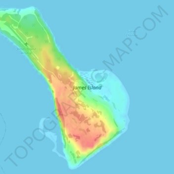
Name: James Island topographic map, elevation, terrain.
Average elevation: 26 ft
Minimum elevation: -3 ft
Maximum elevation: 207 ft
Other topographic maps
Click on a map to view its topography, its elevation and its terrain.
Mayne
Canada > British Columbia > Capital Regional District > Southern Gulf Islands Electoral Area
Average elevation: 171 ft
Mount Parke
Canada > British Columbia > Capital Regional District > Southern Gulf Islands Electoral Area
Average elevation: 243 ft
Galiano
Canada > British Columbia > Capital Regional District > Southern Gulf Islands Electoral Area
Average elevation: 269 ft
Mayne
Canada > British Columbia > Capital Regional District > Southern Gulf Islands Electoral Area
Average elevation: 171 ft
Mayne
Canada > British Columbia > Capital Regional District > Southern Gulf Islands Electoral Area
Average elevation: 171 ft