Geolocate

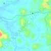
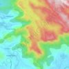
Perambra topographic map

Click on the map to display elevation.

About this map

Name: Perambra topographic map, elevation, terrain.

Location: Perambra, Koyilandi, Kozhikode, Kerala, 673525, India (11.51973 75.71812 11.59973 75.79812)

Average elevation: 89 ft

Minimum elevation: 7 ft

Maximum elevation: 456 ft

Other topographic maps

Click on a map to view its topography, its elevation and its terrain.
Kayanna

India > Kerala > Koyilandi > Kayanna Bazar

Average elevation: 220 ft

vayalada

India > Kerala > Koyilandi > Vattachira

Average elevation: 702 ft

Moodadi

India > Kerala > Koyilandi > Thikkodi

Average elevation: 33 ft

Balussery

India > Kerala > Koyilandi > Balusseri

Average elevation: 128 ft

Kariyathumpara

India > Kerala > Koyilandi > Vallayil Thazhe

Average elevation: 1,781 ft

Malabar WLS

India > Kerala > Koyilandi > Vythiri

Average elevation: 3,058 ft

Kuttiyadi river

India > Kerala > Koyilandi > Peruvannamuzhi

Average elevation: 367 ft

Balussery

India > Kerala > Koyilandi > Panayi

Average elevation: 128 ft

Unnikulam

India > Kerala > Koyilandi > Karumala

Average elevation: 171 ft

Gear up for your next adventure:

👟Men's Trail Runners - Lightweight footwear for fast-paced exploration and light hiking
🧥Waterproof Jacket for Hiking - Breathable and rugged rain jacket for outdoor excursions
🧦Merino Wool Socks - Moisture-wicking, blister-preventing socks for long treks
🧤Tactile Hiking Gloves - Keep hands warm while operating GPS and smartphone screens
📦Dry Bags Set - Waterproof storage for electronics and clothes

As an Amazon Associate, this site earns from qualifying purchases at no extra cost to you.