Geolocate

Felanich topographic map

Click on the map to display elevation.

About this map

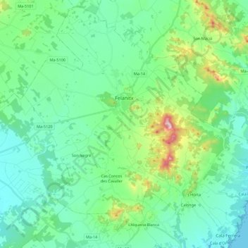
Name: Felanich topographic map, elevation, terrain.

Location: Felanich, Migjorn, Balearic Islands, Spain (39.37598 3.05969 39.53531 3.27725)

Average elevation: 331 ft

Minimum elevation: 0 ft

Maximum elevation: 1,545 ft

Other topographic maps

Click on a map to view its topography, its elevation and its terrain.

Cala Llombards

Spain > Balearic Islands > Migjorn

Average elevation: 62 ft

Badia Blava

Spain > Balearic Islands > Migjorn > Llucmajor

Average elevation: 289 ft

Portopetro

Spain > Balearic Islands > Migjorn > Santanyí

Average elevation: 52 ft

Cala d'Or

Spain > Balearic Islands > Migjorn > Santanyí

Average elevation: 56 ft

Es Camp Alt

Spain > Balearic Islands > Migjorn

Average elevation: 341 ft

Cala Egos

Spain > Balearic Islands > Migjorn > Santanyí

Average elevation: 36 ft

Calonge

Spain > Balearic Islands > Migjorn > Santanyí

Average elevation: 269 ft

sa Mola

Spain > Balearic Islands > Migjorn > Felanich

Average elevation: 354 ft

Gear up for your next adventure:

👓Polarized Sunglasses - Outdoor sunglasses for glare reduction
❄️Traction Cleats - Prevent slips on icy trails during winter hikes
🧭Outdoor Navigation Book - Learn advanced navigation skills
🦺Reflective Outdoor Gear - Safety gear for low‑light conditions
🛰️Handheld GPS Units - Professional satellite navigators for precise backcountry mapping

As an Amazon Associate, this site earns from qualifying purchases at no extra cost to you.