Geolocate

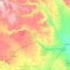
Bulaale topographic map

Click on the map to display elevation.

About this map

Name: Bulaale topographic map, elevation, terrain.

Location: Bulaale, Jarar, Somali Region, Ethiopia (7.92680 43.78903 7.96680 43.82903)

Average elevation: 3,012 ft

Minimum elevation: 2,946 ft

Maximum elevation: 3,087 ft

Other topographic maps

Click on a map to view its topography, its elevation and its terrain.

Dollo

Ethiopia > Somali Region

Average elevation: 1,909 ft

Liben

Ethiopia > Somali Region

Average elevation: 2,516 ft

Gear up for your next adventure:

💧Water Purification System - Clean water on the trail with reliable purifiers
📷Action Cameras - Rugged cameras to document your journeys across rugged terrain
🎒Day Hiking Backpack - Lightweight backpack perfect for day trips and outdoor adventures
🪄Magnetic Compass - Accurate compass for navigation
🗺️NatGeo Topo Maps - High-quality waterproof printed topographic maps of US Parks

As an Amazon Associate, this site earns from qualifying purchases at no extra cost to you.