
Thank you for supporting this site ❤️
Make a donation
Make a donation
Gear up for your next adventure:
As an Amazon Associate, this site earns from qualifying purchases at no extra cost to you.
Grad Orahovica topographic map
Click on the map to display elevation.
Thank you for supporting this site ❤️
Make a donation
Make a donation
Gear up for your next adventure:
As an Amazon Associate, this site earns from qualifying purchases at no extra cost to you.
About this map
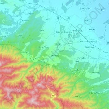
Name: Grad Orahovica topographic map, elevation, terrain.
Location: Grad Orahovica, Virovitica-Podravina County, 33515, Croatia (45.47256 17.73737 45.58823 17.97844)
Average elevation: 883 ft
Minimum elevation: 325 ft
Maximum elevation: 2,530 ft
Thank you for supporting this site ❤️
Make a donation
Make a donation
Gear up for your next adventure:
As an Amazon Associate, this site earns from qualifying purchases at no extra cost to you.
Other topographic maps
Click on a map to view its topography, its elevation and its terrain.
Sjevernjak
Croatia > Virovitica-Podravina County > Grad Virovitica > Rezovac
Average elevation: 479 ft