Geolocate

Urawade topographic map

Click on the map to display elevation.

About this map

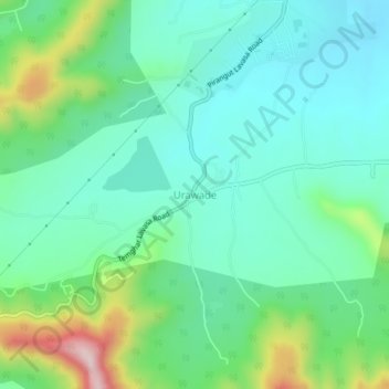
Name: Urawade topographic map, elevation, terrain.

Location: Urawade, Mulshi, Maharashtra, India (18.46270 73.64364 18.50270 73.68364)

Average elevation: 2,257 ft

Minimum elevation: 1,919 ft

Maximum elevation: 3,241 ft

Other topographic maps

Click on a map to view its topography, its elevation and its terrain.

Aamby Valley

India > Maharashtra > Mulshi

Average elevation: 2,329 ft

Manas Lake

India > Maharashtra > Mulshi > Bhukum

Average elevation: 2,306 ft

Mulshi Lake

India > Maharashtra > Mulshi > Chachivali

Average elevation: 2,329 ft

Katarkhadak

India > Maharashtra > Mulshi

Average elevation: 2,657 ft

Mula

India > Maharashtra > Mulshi

Average elevation: 2,159 ft

Kasarsai

India > Maharashtra > Mulshi > Nere

Average elevation: 1,985 ft

Gear up for your next adventure:

🧭Map Reading Tools - Tools and kits for map navigation
🧭Pro Hiking Compasses - High-accuracy liquid-filled compasses for topographic orientation
🧯Portable Fire Pit - Compact fire pit for camping spots
🧼Biodegradable Camping Soap - Eco‑friendly soap for outdoor hygiene
🌡️Handheld Weather Meters - Measure wind, temp, and pressure for safe mountain travel

As an Amazon Associate, this site earns from qualifying purchases at no extra cost to you.