Geolocate

Romeoville topographic map

Click on the map to display elevation.

About this map
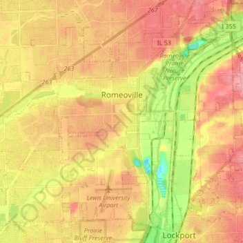
Name: Romeoville topographic map, elevation, terrain.

Location: Romeoville, Will County, Illinois, 60446, United States (41.59269 -88.16311 41.67988 -88.02857)

Average elevation: 643 ft

Minimum elevation: 472 ft

Maximum elevation: 755 ft

Will County trails, hiking, mountain biking, running and outdoor activities

Other topographic maps

Click on a map to view its topography, its elevation and its terrain.

Marley

United States > Illinois > Will County

Average elevation: 702 ft

Drummond

United States > Illinois > Will County

Average elevation: 548 ft

Welco Corners

United States > Illinois > Will County > Bolingbrook

Average elevation: 719 ft

Puddle Pond

United States > Illinois > Will County > Plainfield

Average elevation: 614 ft

Arbury Hills

United States > Illinois > Will County

Average elevation: 709 ft

Gear up for your next adventure:

👓Polarized Sunglasses - Outdoor sunglasses for glare reduction
🧣Hiking Neck Gaiter - Multi‑use neck protection for outdoor weather
🪶Camp Gear Gift Set - Perfect gift bundle for outdoor fans
📱Solar Portable Charger - Solar power bank for charging devices off‑grid
🔌USB Car Charger - Car charger for on‑the‑go power needs

As an Amazon Associate, this site earns from qualifying purchases at no extra cost to you.