
Make a donation
Gear up for your next adventure:
As an Amazon Associate, this site earns from qualifying purchases at no extra cost to you.
Bocking topographic map
Click on the map to display elevation.
Make a donation
Gear up for your next adventure:
As an Amazon Associate, this site earns from qualifying purchases at no extra cost to you.
About this map
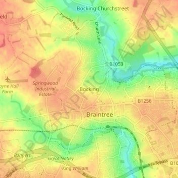
Name: Bocking topographic map, elevation, terrain.
Location: Bocking, Braintree, Essex, England, CM7 2TB, United Kingdom (51.86381 0.52991 51.90381 0.56991)
Average elevation: 207 ft
Minimum elevation: 115 ft
Maximum elevation: 262 ft
Make a donation
Gear up for your next adventure:
As an Amazon Associate, this site earns from qualifying purchases at no extra cost to you.
Other topographic maps
Click on a map to view its topography, its elevation and its terrain.
Hedingham Castle
United Kingdom > England > Essex > Braintree > Castle Hedingham
Average elevation: 220 ft
Make a donation
Gear up for your next adventure:
As an Amazon Associate, this site earns from qualifying purchases at no extra cost to you.
Helions Bumpstead
United Kingdom > England > Essex > Braintree > Helions Bumpstead
Average elevation: 335 ft
Make a donation
Gear up for your next adventure:
As an Amazon Associate, this site earns from qualifying purchases at no extra cost to you.
Great Maplestead
United Kingdom > England > Essex > Braintree > Great Maplestead
Average elevation: 217 ft
Make a donation
Gear up for your next adventure:
As an Amazon Associate, this site earns from qualifying purchases at no extra cost to you.
Tilbury Juxta Clare
United Kingdom > England > Essex > Braintree > Tilbury juxta Clare
Average elevation: 253 ft
Make a donation
Gear up for your next adventure:
As an Amazon Associate, this site earns from qualifying purchases at no extra cost to you.
Make a donation
Gear up for your next adventure:
As an Amazon Associate, this site earns from qualifying purchases at no extra cost to you.