
Make a donation
Gear up for your next adventure:
As an Amazon Associate, this site earns from qualifying purchases at no extra cost to you.
Lake Placid topographic map
Click on the map to display elevation.
Make a donation
Gear up for your next adventure:
As an Amazon Associate, this site earns from qualifying purchases at no extra cost to you.
Lake Placid
Lake Placid, located in Highlands County, Florida, is situated on relatively flat terrain characteristic of the Florida Peninsula. The town's average elevation is approximately 150 feet (46 meters) above sea level, with elevations ranging from a minimum of about 69 feet (21 meters) to a maximum of about 165 feet (50 meters). This gentle topography is typical of the region, contributing to the area's suitability for agriculture and outdoor recreational activities. The landscape is predominantly flat, with subtle undulations and low-lying areas, interspersed with numerous lakes and wetlands that enhance the area's natural beauty. The presence of these water bodies, such as Lake Placid itself, adds to the scenic charm and ecological diversity of the region.
Make a donation
Gear up for your next adventure:
As an Amazon Associate, this site earns from qualifying purchases at no extra cost to you.
About this map
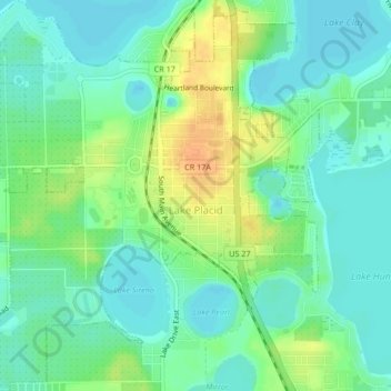
Name: Lake Placid topographic map, elevation, terrain.
Location: Lake Placid, Highlands County, Florida, 33852, United States (27.27582 -81.39029 27.31301 -81.34960)
Average elevation: 105 ft
Minimum elevation: 66 ft
Maximum elevation: 174 ft
Highlands County trails, hiking, mountain biking, running and outdoor activities
Make a donation
Gear up for your next adventure:
As an Amazon Associate, this site earns from qualifying purchases at no extra cost to you.
Other topographic maps
Click on a map to view its topography, its elevation and its terrain.
Make a donation
Gear up for your next adventure:
As an Amazon Associate, this site earns from qualifying purchases at no extra cost to you.
Make a donation
Gear up for your next adventure:
As an Amazon Associate, this site earns from qualifying purchases at no extra cost to you.