Geolocate

Howick topographic map

Click on the map to display elevation.

About this map

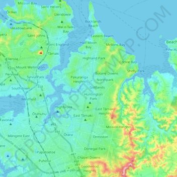
Name: Howick topographic map, elevation, terrain.

Location: Howick, Auckland, New Zealand (-37.00173 174.85646 -36.84578 174.96843)

Average elevation: 89 ft

Minimum elevation: -3 ft

Maximum elevation: 564 ft

Other topographic maps

Click on a map to view its topography, its elevation and its terrain.

Lake Panorama

New Zealand > Auckland > Henderson-Massey

Average elevation: 171 ft

Pukekohe

New Zealand > Auckland > Franklin

Average elevation: 256 ft

Waiari Reserve

New Zealand > Auckland > Papakura

Average elevation: 39 ft

Wilson's Beach

New Zealand > Auckland > Ōrākei

Average elevation: 69 ft

Omaha Beach

New Zealand > Auckland > Rodney > Omaha

Average elevation: 10 ft

Maraetai

New Zealand > Auckland > Franklin > Maraetai

Average elevation: 72 ft

Gear up for your next adventure:

🗺️NatGeo Topo Maps - High-quality waterproof printed topographic maps of US Parks
🔪Outdoor Multitools - Essential survival tools for gear repair and field use
🌎3D Topographic Globes - Raised relief globes for a tactile understanding of geography
🦟Ultrasonic Repellers - Create a bug-free zone at your camp or rest stop
🪶Camping Sleeping Pad - Comfortable sleeping pad for backpacking

As an Amazon Associate, this site earns from qualifying purchases at no extra cost to you.