Geolocate

Coalhall topographic map

Click on the map to display elevation.

About this map

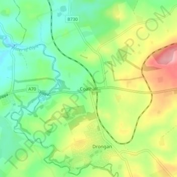
Name: Coalhall topographic map, elevation, terrain.

Location: Coalhall, East Ayrshire, Scotland, KA6 6ND, United Kingdom (55.42800 -4.48356 55.46800 -4.44356)

Average elevation: 341 ft

Minimum elevation: 187 ft

Maximum elevation: 597 ft

Other topographic maps

Click on a map to view its topography, its elevation and its terrain.

Glenbuck Loch

United Kingdom > Scotland > East Ayrshire

Average elevation: 1,073 ft

River Doon

United Kingdom > Scotland > East Ayrshire > Dalrymple

Average elevation: 551 ft

River Ayr

United Kingdom > Scotland > East Ayrshire

Average elevation: 689 ft

Braid Wood

United Kingdom > Scotland > East Ayrshire

Average elevation: 374 ft

Loch Doon

United Kingdom > Scotland > East Ayrshire

Average elevation: 955 ft

Gear up for your next adventure:

🏥Hiking First Aid Kits - Comprehensive medical kits for remote trail injuries
🎁Geography Themed Gifts - Unique gift ideas for map lovers and geography enthusiasts
🧭Compass with Lanyard - Easy‑carry compass for navigation
🪶LED Camping Lantern - Bright lantern for camp lighting
🦶Carbon Trekking Poles - Reduce knee impact on steep descents with ultra-light poles

As an Amazon Associate, this site earns from qualifying purchases at no extra cost to you.