
Make a donation
Gear up for your next adventure:
As an Amazon Associate, this site earns from qualifying purchases at no extra cost to you.
Ripton topographic map
Click on the map to display elevation.
Make a donation
Gear up for your next adventure:
As an Amazon Associate, this site earns from qualifying purchases at no extra cost to you.
About this map
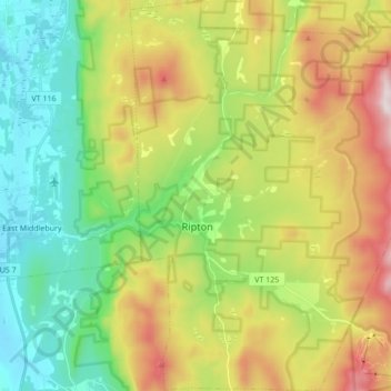
Name: Ripton topographic map, elevation, terrain.
Location: Ripton, Addison County, Vermont, 05766, United States (43.92197 -73.06332 44.04501 -72.90591)
Average elevation: 1,444 ft
Minimum elevation: 364 ft
Maximum elevation: 3,255 ft
Addison County trails, hiking, mountain biking, running and outdoor activities
Make a donation
Gear up for your next adventure:
As an Amazon Associate, this site earns from qualifying purchases at no extra cost to you.
Other topographic maps
Click on a map to view its topography, its elevation and its terrain.
Make a donation
Gear up for your next adventure:
As an Amazon Associate, this site earns from qualifying purchases at no extra cost to you.
Weybridge Hill
United States > Vermont > Addison County > Weybridge > Weybridge Hill
Average elevation: 312 ft
Make a donation
Gear up for your next adventure:
As an Amazon Associate, this site earns from qualifying purchases at no extra cost to you.