
Make a donation
Gear up for your next adventure:
As an Amazon Associate, this site earns from qualifying purchases at no extra cost to you.
Bramois topographic map
Click on the map to display elevation.
Make a donation
Gear up for your next adventure:
As an Amazon Associate, this site earns from qualifying purchases at no extra cost to you.
About this map
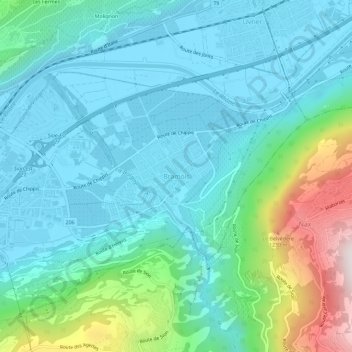
Name: Bramois topographic map, elevation, terrain.
Location: Bramois, Sion, Valais, 1967, Suisse (46.21218 7.38390 46.25218 7.42390)
Average elevation: 2,267 ft
Minimum elevation: 1,601 ft
Maximum elevation: 4,823 ft
Make a donation
Gear up for your next adventure:
As an Amazon Associate, this site earns from qualifying purchases at no extra cost to you.
Other topographic maps
Click on a map to view its topography, its elevation and its terrain.
Les Agettes
Suisse > Valais > Sion > Sion > Les Agettes
Les Agettes est une ancienne commune suisse du canton du Valais, située dans le district de Sion entre 980 et 2 200 mètres d'altitude.
Average elevation: 4,577 ft