Make a donation
Gear up for your next adventure:
As an Amazon Associate, this site earns from qualifying purchases at no extra cost to you.
Henfield topographic map
Click on the map to display elevation.
Make a donation
Gear up for your next adventure:
As an Amazon Associate, this site earns from qualifying purchases at no extra cost to you.
About this map
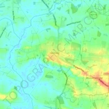
Name: Henfield topographic map, elevation, terrain.
Location: Henfield, Horsham, West Sussex, England, United Kingdom (50.90320 -0.31034 50.95664 -0.24418)
Average elevation: 46 ft
Minimum elevation: -7 ft
Maximum elevation: 171 ft
Make a donation
Gear up for your next adventure:
As an Amazon Associate, this site earns from qualifying purchases at no extra cost to you.
Other topographic maps
Click on a map to view its topography, its elevation and its terrain.
Make a donation
Gear up for your next adventure:
As an Amazon Associate, this site earns from qualifying purchases at no extra cost to you.
Make a donation
Gear up for your next adventure:
As an Amazon Associate, this site earns from qualifying purchases at no extra cost to you.
Gay Street
United Kingdom > England > West Sussex > Horsham > West Chiltington
Average elevation: 125 ft
Make a donation
Gear up for your next adventure:
As an Amazon Associate, this site earns from qualifying purchases at no extra cost to you.
Sullington Warren
United Kingdom > England > West Sussex > Horsham > Storrington
Average elevation: 177 ft
Make a donation
Gear up for your next adventure:
As an Amazon Associate, this site earns from qualifying purchases at no extra cost to you.
Smock Alley
United Kingdom > England > West Sussex > Horsham > West Chiltington Common
Average elevation: 125 ft
