
Make a donation
Gear up for your next adventure:
As an Amazon Associate, this site earns from qualifying purchases at no extra cost to you.
Glapwell topographic map
Click on the map to display elevation.
Make a donation
Gear up for your next adventure:
As an Amazon Associate, this site earns from qualifying purchases at no extra cost to you.
Glapwell
Glapwell is a rural village and civil parish on the A617 road in the Bolsover District of north-east Derbyshire, The village is at the top of a steep hill at an elevation of 176m, on the western edge of the Southern Magnesian Limestone] overlooking the valley of the River Doe Lea (formerly known as the Dorley). It lies between Chesterfield (7 miles to the north-west), Mansfield (5 miles to the south), and Bolsover (3 miles to the north), and had a population of 1,503 at the 2011 Census.
Make a donation
Gear up for your next adventure:
As an Amazon Associate, this site earns from qualifying purchases at no extra cost to you.
About this map
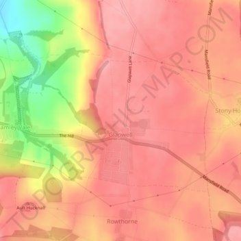
Name: Glapwell topographic map, elevation, terrain.
Location: Glapwell, Bolsover, Derbyshire, England, United Kingdom (53.18360 -1.30299 53.19947 -1.26816)
Average elevation: 512 ft
Minimum elevation: 259 ft
Maximum elevation: 604 ft
Make a donation
Gear up for your next adventure:
As an Amazon Associate, this site earns from qualifying purchases at no extra cost to you.
Other topographic maps
Click on a map to view its topography, its elevation and its terrain.
Make a donation
Gear up for your next adventure:
As an Amazon Associate, this site earns from qualifying purchases at no extra cost to you.
Creswell Model Village
United Kingdom > England > Derbyshire > Bolsover > Creswell Model Village
Average elevation: 331 ft
Make a donation
Gear up for your next adventure:
As an Amazon Associate, this site earns from qualifying purchases at no extra cost to you.