
Make a donation
Gear up for your next adventure:
As an Amazon Associate, this site earns from qualifying purchases at no extra cost to you.
Palterton topographic map
Click on the map to display elevation.
Make a donation
Gear up for your next adventure:
As an Amazon Associate, this site earns from qualifying purchases at no extra cost to you.
About this map
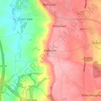
Name: Palterton topographic map, elevation, terrain.
Average elevation: 436 ft
Minimum elevation: 207 ft
Maximum elevation: 604 ft
Make a donation
Gear up for your next adventure:
As an Amazon Associate, this site earns from qualifying purchases at no extra cost to you.
Other topographic maps
Click on a map to view its topography, its elevation and its terrain.
Make a donation
Gear up for your next adventure:
As an Amazon Associate, this site earns from qualifying purchases at no extra cost to you.
Glapwell
United Kingdom > England > Derbyshire > Bolsover
Glapwell is a rural village and civil parish on the A617 road in the Bolsover District of north-east Derbyshire, The village is at the top of a steep hill at an elevation of 176m, on the western edge of the Southern Magnesian Limestone] overlooking the valley of the River Doe Lea (formerly known as the…
Average elevation: 512 ft
Make a donation
Gear up for your next adventure:
As an Amazon Associate, this site earns from qualifying purchases at no extra cost to you.
Make a donation
Gear up for your next adventure:
As an Amazon Associate, this site earns from qualifying purchases at no extra cost to you.