Geolocate

Magnolia topographic map

Click on the map to display elevation.

About this map

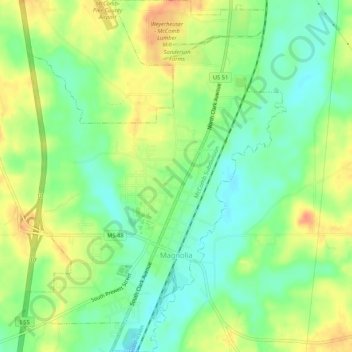
Name: Magnolia topographic map, elevation, terrain.

Location: Magnolia, Pike County, Mississippi, United States (31.13076 -90.48198 31.17593 -90.44226)

Average elevation: 344 ft

Minimum elevation: 276 ft

Maximum elevation: 427 ft

Pike County trails, hiking, mountain biking, running and outdoor activities

Other topographic maps

Click on a map to view its topography, its elevation and its terrain.

Topisaw

United States > Mississippi > Pike County

Average elevation: 371 ft

Chatawa

United States > Mississippi > Pike County

Average elevation: 308 ft

McComb

United States > Mississippi > Pike County > McComb > McComb

Average elevation: 413 ft

Gear up for your next adventure:

☀️Outdoor Sunscreen - High protection sunscreen for outdoor activities
🕶️GPS Smartphone Mount - Secure mount for phone navigation
🪶Fire Starter Kit - Reliable fire starter for survival and camping
📡Handheld GPS Device - Reliable handheld GPS for outdoor navigation
🔭Stargazing Telescopes - Perfect for camping in low-light pollution areas shown on maps

As an Amazon Associate, this site earns from qualifying purchases at no extra cost to you.