
Make a donation
Gear up for your next adventure:
As an Amazon Associate, this site earns from qualifying purchases at no extra cost to you.
Huejotzingo topographic map
Click on the map to display elevation.
Make a donation
Gear up for your next adventure:
As an Amazon Associate, this site earns from qualifying purchases at no extra cost to you.
Huejotzingo
Huejotzingo is located on the slopes of the Sierra Nevada, 25 km northwest from the capital on Highway 150. The geography of the land varies depending on the proximity to the Sierra Nevada. Areas at altitudes under 2,500 masl on the far east side are part of the Valley of Puebla, more specifically the plains of Huejotzingo. Between 2,500 and 3,000 m a.s.l. are the lower slopes of the Sierra Nevada, and above this on the far west side, the territory is part of the mountain chain and the Trans-Mexican Volcanic Belt. The east side of the municipality is flat. Heading west, the land begins to rise gradually in the middle of the territory, then the altitude increases sharply on the west end, as it is the foot of the Iztaccíhuatl volcano. Near this volcano, there are a number of other elevations such as Ocotepec, Tepechichipa and Zacatalatla. The steepness of the Iztaccíhuatl volcano makes it prone to rockslides as snowmelt runs down the side, especially from a depression on the side where snow tends to accumulate, called Ayolócotl. Visible along various areas of the volcano are areas devoid of vegetation where rockslides have violently disrupted the ecology.
Make a donation
Gear up for your next adventure:
As an Amazon Associate, this site earns from qualifying purchases at no extra cost to you.
About this map
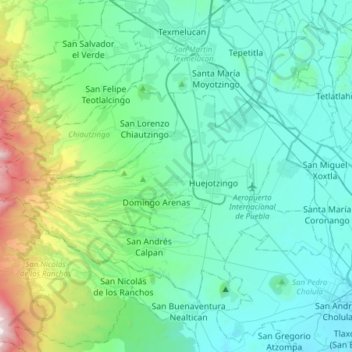
Name: Huejotzingo topographic map, elevation, terrain.
Location: Huejotzingo, Puebla, Mexico (19.09335 -98.64031 19.23523 -98.33068)
Average elevation: 7,992 ft
Minimum elevation: 6,965 ft
Maximum elevation: 12,927 ft
Make a donation
Gear up for your next adventure:
As an Amazon Associate, this site earns from qualifying purchases at no extra cost to you.
Other topographic maps
Click on a map to view its topography, its elevation and its terrain.
Pico de Orizaba
Mexico > Puebla > Chalchicomula de Sesma
Citlaltépetl (from Náhuatl citlal(in) = star, and tepētl = mountain), otherwise known as Pico de Orizaba, is an active volcano and the highest in North America, as well as the highest mountain in Mexico and third highest peak in North America, after Denali/Mount McKinley of the United States and Mount Logan…
Average elevation: 16,302 ft
Popocatépetl
Mexico > Puebla > Tochimilco
According to paleomagnetic studies, the volcano is about 730,000 years old. It is cone shaped with a diameter of 25 km (16 mi) at its base, with a peak elevation of 5,450 m (17,880 ft). The crater is elliptical with an orientation northeast-southwest. The walls of the crater vary from 600 to 840 m (1,970 to…
Average elevation: 15,771 ft
Borrego
Mexico > Puebla > Chalchicomula de Sesma > Santa María Techachalco
Average elevation: 8,425 ft
Make a donation
Gear up for your next adventure:
As an Amazon Associate, this site earns from qualifying purchases at no extra cost to you.
Puebla
Mexico > Puebla > Municipio de Puebla
Most of its mountains belong to the Sierra Madre Oriental and the Trans-Mexican Volcanic Belt. The first is locally called the Sierra Norte del Puebla, entering the state from the northwest and then breaks up into the smaller chains of Sierra de Zacapoaxtla, Sierra de Huauchinango, Sierra de Teziutlán, Sierra…
Average elevation: 7,326 ft
Iztaccíhuatl
Mexico > Puebla > San Salvador el Verde
The name "Iztaccíhuatl" is Nahuatl for "White (like salt) woman", reflecting the four individual snow-capped peaks which depict the head, chest, knees and feet of a sleeping female when seen from east or west. Iztaccíhuatl is to the north of its twin Popocatépetl, to which it is connected by the high…
Average elevation: 15,525 ft
Make a donation
Gear up for your next adventure:
As an Amazon Associate, this site earns from qualifying purchases at no extra cost to you.
Pico de Orizaba
Mexico > Puebla > Chalchicomula de Sesma
Citlaltépetl (from Náhuatl citlal(in) = star, and tepētl = mountain), otherwise known as Pico de Orizaba, is an active volcano and the highest in North America, as well as the highest mountain in Mexico and third highest peak in North America, after Denali/Mount McKinley of the United States and Mount Logan…
Average elevation: 16,302 ft
Puebla City
Mexico > Puebla > Municipio de Puebla
The Sierra del Tentzon and higher elevations of Malinche volcano still conserve the Trans-Mexican Volcanic Belt pine-oak forests ecoregion – with forests of pine, holm oak and other tree species. In the pine forests, Montezuma Pine (Pinus montezumae) is generally predominant, with Hartweg's Pine (Pinus…
Average elevation: 7,326 ft
Make a donation
Gear up for your next adventure:
As an Amazon Associate, this site earns from qualifying purchases at no extra cost to you.
Popocatépetl
Mexico > Puebla > Tochimilco
According to paleomagnetic studies, the volcano is about 730,000 years old. It is cone shaped with a diameter of 25 km (16 mi) at its base, with a peak elevation of 5,450 m (17,880 ft). The crater is elliptical with an orientation northeast-southwest. The walls of the crater vary from 600 to 840 m (1,970 to…
Average elevation: 15,771 ft
Iztaccíhuatl
Mexico > Puebla > San Salvador el Verde
The name "Iztaccíhuatl" is Nahuatl for "White (like salt) woman", reflecting the four individual snow-capped peaks which depict the head, chest, knees and feet of a sleeping female when seen from east or west. Iztaccíhuatl is to the north of its twin Popocatépetl, to which it is connected by the high…
Average elevation: 15,525 ft
Make a donation
Gear up for your next adventure:
As an Amazon Associate, this site earns from qualifying purchases at no extra cost to you.
Atlixco
The city of Atlixco is in the west of the state of Puebla at an elevation of 1,881 meters above sea level, 25 km from the state capital of Puebla. The main economic activities of the city are agriculture and basic commerce. It lies at the foot of the Cerro de San Miguel mountain, which is the main geographical…
Average elevation: 6,145 ft
Make a donation
Gear up for your next adventure:
As an Amazon Associate, this site earns from qualifying purchases at no extra cost to you.
Make a donation
Gear up for your next adventure:
As an Amazon Associate, this site earns from qualifying purchases at no extra cost to you.
Make a donation
Gear up for your next adventure:
As an Amazon Associate, this site earns from qualifying purchases at no extra cost to you.
Make a donation
Gear up for your next adventure:
As an Amazon Associate, this site earns from qualifying purchases at no extra cost to you.
San Antonio Cacalotepec
Mexico > Puebla > San Andrés Cholula > San Bernardino Tlaxcalancingo
Average elevation: 6,932 ft
Make a donation
Gear up for your next adventure:
As an Amazon Associate, this site earns from qualifying purchases at no extra cost to you.
Pico de Orizaba
Mexico > Puebla > Chalchicomula de Sesma
Pico de Orizaba, also known as Citlaltépetl (from Nahuatl citlal(in) = star, and tepētl = mountain), is an active volcano, the highest mountain in Mexico and third highest in North America, after Denali of United States and Mount Logan of Canada. Pico de Orizaba is also the highest volcano in North America.…
Average elevation: 16,302 ft
Make a donation
Gear up for your next adventure:
As an Amazon Associate, this site earns from qualifying purchases at no extra cost to you.
Cholula de Rivadavia
Mexico > Puebla > San Pedro Cholula > Cholula de Rivadavia
Average elevation: 7,070 ft
Make a donation
Gear up for your next adventure:
As an Amazon Associate, this site earns from qualifying purchases at no extra cost to you.