Geolocate

Redwater topographic map

Click on the map to display elevation.

About this map

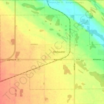
Name: Redwater topographic map, elevation, terrain.

Location: Redwater, Town of Redwater, Alberta, T0A 2W0, Canada (53.93436 -113.16166 53.97077 -113.07521)

Average elevation: 2,060 ft

Minimum elevation: 1,975 ft

Maximum elevation: 2,126 ft

Gear up for your next adventure:

🧭Outdoor Navigation Book - Learn advanced navigation skills
🧤Hiking Gloves - Protective gloves for rugged trails
🚁Photography Drones - Capture stunning aerial views of landforms and topography
🛠️Backpacking Tool Kit - Essential toolkit for outdoor repairs
🏔️Mountain Trail Maps - High‑detail maps for popular peaks

As an Amazon Associate, this site earns from qualifying purchases at no extra cost to you.