
Heath topographic map
Click on the map to display elevation.
About this map
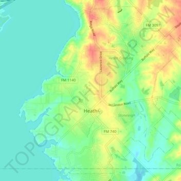
Name: Heath topographic map, elevation, terrain.
Location: Heath, Rockwall County, Texas, United States (32.81156 -96.50840 32.87738 -96.42421)
Average elevation: 479 ft
Minimum elevation: 423 ft
Maximum elevation: 581 ft
Rockwall County trails, hiking, mountain biking, running and outdoor activities
Other topographic maps
Click on a map to view its topography, its elevation and its terrain.