Geolocate

High Point topographic map

Click on the map to display elevation.

About this map

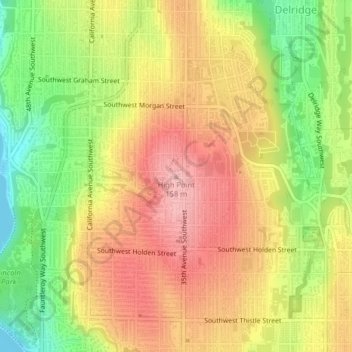
Name: High Point topographic map, elevation, terrain.

Location: High Point, Seattle, King County, Washington, 98126, United States (47.53926 -122.37751 47.53936 -122.37741)

Average elevation: 289 ft

Minimum elevation: 0 ft

Maximum elevation: 525 ft

King County trails, hiking, mountain biking, running and outdoor activities

Other topographic maps

Click on a map to view its topography, its elevation and its terrain.

Gas Works Park

United States > Washington > King County > Seattle

Average elevation: 125 ft

Carkeek Park

United States > Washington > King County > Seattle

Average elevation: 210 ft

Discovery Park

United States > Washington > King County > Seattle

Average elevation: 92 ft

Kerry Park

United States > Washington > King County > Seattle

Average elevation: 171 ft

Green Lake Park

United States > Washington > King County > Seattle

Average elevation: 240 ft

Portage Bay

United States > Washington > King County > Seattle

Average elevation: 92 ft

Sturgus Park

United States > Washington > King County > Seattle

Average elevation: 167 ft

Jefferson Park

United States > Washington > King County > Seattle

Average elevation: 171 ft

Seattle Center

United States > Washington > King County > Seattle

Average elevation: 121 ft

Chinatown

United States > Washington > King County > Seattle

Average elevation: 135 ft

Alki Beach

United States > Washington > King County > Seattle

Average elevation: 105 ft

Harbor Island

United States > Washington > King County > Seattle

Average elevation: 13 ft

Little Saigon

United States > Washington > King County > Seattle

Average elevation: 177 ft

Shilshole Bay

United States > Washington > King County > Seattle

Average elevation: 56 ft

Woodland Park

United States > Washington > King County > Seattle

Average elevation: 233 ft

Nantes Park

United States > Washington > King County > Seattle

Average elevation: 174 ft

Lemur

United States > Washington > King County > Seattle

Average elevation: 194 ft

Gear up for your next adventure:

🌡️Portable Weather Meter - Track weather conditions on the trail
👖Convertible Hiking Pants - Versatile zip-off pants for changing altitudes and temperatures
🧤Tactile Hiking Gloves - Keep hands warm while operating GPS and smartphone screens
🖼️Topo Map Wall Art - Decorative topographic prints of famous peaks and regions
🩹Survival Bandages - High‑quality bandages for emergencies

As an Amazon Associate, this site earns from qualifying purchases at no extra cost to you.