
Ocotepeque topographic map
Interactive map
Click on the map to display elevation.
About this map
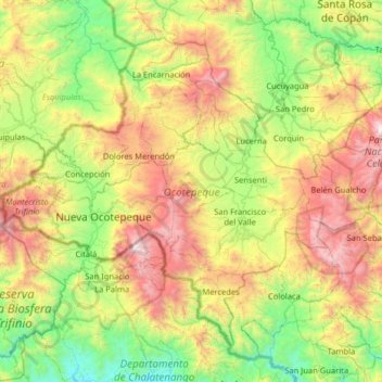
Name: Ocotepeque topographic map, elevation, terrain.
Location: Ocotepeque, Honduras (14.22520 -89.35682 14.72678 -88.71447)
Average elevation: 3,806 ft
Minimum elevation: 1,043 ft
Maximum elevation: 8,865 ft
Other topographic maps
Click on a map to view its topography, its elevation and its terrain.
Belén Gualcho
Honduras > Ocotepeque > Belén Gualcho
Belén Gualcho, Ocotepeque, Honduras
Average elevation: 5,791 ft
Dolores Merendón
Honduras > Ocotepeque > Dolores Merendón
Dolores Merendón, Ocotepeque, Honduras
Average elevation: 5,059 ft