
Make a donation
Gear up for your next adventure:
As an Amazon Associate, this site earns from qualifying purchases at no extra cost to you.
Canoas topographic map
Click on the map to display elevation.
Make a donation
Gear up for your next adventure:
As an Amazon Associate, this site earns from qualifying purchases at no extra cost to you.
Canoas
Atinge uma altitude de oito metros ao nível do mar. Em seu território correm as águas dos rios Gravataí e Sinos.
Make a donation
Gear up for your next adventure:
As an Amazon Associate, this site earns from qualifying purchases at no extra cost to you.
About this map
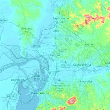
Name: Canoas topographic map, elevation, terrain.
Average elevation: 98 ft
Minimum elevation: -3 ft
Maximum elevation: 1,014 ft
Make a donation
Gear up for your next adventure:
As an Amazon Associate, this site earns from qualifying purchases at no extra cost to you.
Other topographic maps
Click on a map to view its topography, its elevation and its terrain.
Olaria
Brasil > Rio Grande do Sul > Região Metropolitana de Porto Alegre > Canoas
Average elevation: 98 ft
Mathias Velho
Brasil > Rio Grande do Sul > Região Metropolitana de Porto Alegre > Canoas
Average elevation: 16 ft
Rio Branco
Brasil > Rio Grande do Sul > Região Metropolitana de Porto Alegre > Canoas
Average elevation: 16 ft
Marechal Rondon
Brasil > Rio Grande do Sul > Região Metropolitana de Porto Alegre > Canoas
Average elevation: 82 ft
Make a donation
Gear up for your next adventure:
As an Amazon Associate, this site earns from qualifying purchases at no extra cost to you.
Mato Grande
Brasil > Rio Grande do Sul > Região Metropolitana de Porto Alegre > Canoas
Average elevation: 23 ft
Parque Getúlio Vargas
Brasil > Rio Grande do Sul > Região Metropolitana de Porto Alegre > Canoas
Average elevation: 72 ft
Praça Moinhos de Vento II
Brasil > Rio Grande do Sul > Região Metropolitana de Porto Alegre > Canoas
Average elevation: 95 ft
Praça Barão do Rio Branco
Brasil > Rio Grande do Sul > Região Metropolitana de Porto Alegre > Canoas
Average elevation: 33 ft
Make a donation
Gear up for your next adventure:
As an Amazon Associate, this site earns from qualifying purchases at no extra cost to you.
Praça Cristóvão Colombo
Brasil > Rio Grande do Sul > Região Metropolitana de Porto Alegre > Canoas
Average elevation: 30 ft
Arroio Araçá
Brasil > Rio Grande do Sul > Região Metropolitana de Porto Alegre > Canoas
Average elevation: 52 ft
Guajuviras
Brasil > Rio Grande do Sul > Região Metropolitana de Porto Alegre > Canoas
Average elevation: 108 ft
Brigadeira
Brasil > Rio Grande do Sul > Região Metropolitana de Porto Alegre > Canoas
Average elevation: 75 ft
Make a donation
Gear up for your next adventure:
As an Amazon Associate, this site earns from qualifying purchases at no extra cost to you.
Praça Parque São José
Brasil > Rio Grande do Sul > Região Metropolitana de Porto Alegre > Canoas
Average elevation: 62 ft
Harmonia
Brasil > Rio Grande do Sul > Região Metropolitana de Porto Alegre > Canoas
Average elevation: 20 ft
Estância Velha
Brasil > Rio Grande do Sul > Região Metropolitana de Porto Alegre > Canoas
Average elevation: 105 ft
Niterói
Brasil > Rio Grande do Sul > Região Metropolitana de Porto Alegre > Canoas
Average elevation: 23 ft
Make a donation
Gear up for your next adventure:
As an Amazon Associate, this site earns from qualifying purchases at no extra cost to you.
Centro
Brasil > Rio Grande do Sul > Região Metropolitana de Porto Alegre > Canoas
Average elevation: 39 ft
Igara
Brasil > Rio Grande do Sul > Região Metropolitana de Porto Alegre > Canoas
Average elevation: 95 ft
Fátima
Brasil > Rio Grande do Sul > Região Metropolitana de Porto Alegre > Canoas
Average elevation: 20 ft
São José
Brasil > Rio Grande do Sul > Região Metropolitana de Porto Alegre > Canoas
Average elevation: 56 ft
Make a donation
Gear up for your next adventure:
As an Amazon Associate, this site earns from qualifying purchases at no extra cost to you.
Praça Julio Pereira de Souza
Brasil > Rio Grande do Sul > Região Metropolitana de Porto Alegre > Canoas
Average elevation: 112 ft
Praça Hércules
Brasil > Rio Grande do Sul > Região Metropolitana de Porto Alegre > Canoas
Average elevation: 95 ft
Largo Inconfidencia
Brasil > Rio Grande do Sul > Região Metropolitana de Porto Alegre > Canoas
Average elevation: 59 ft