
Make a donation
Gear up for your next adventure:
As an Amazon Associate, this site earns from qualifying purchases at no extra cost to you.
Praça Moinhos de Vento II topographic map
Click on the map to display elevation.
Make a donation
Gear up for your next adventure:
As an Amazon Associate, this site earns from qualifying purchases at no extra cost to you.
About this map
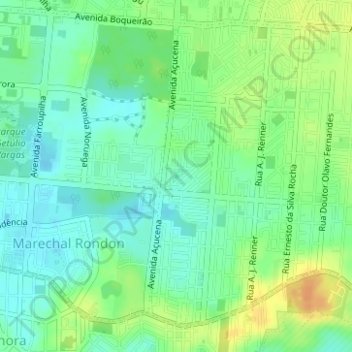
Name: Praça Moinhos de Vento II topographic map, elevation, terrain.
Average elevation: 95 ft
Minimum elevation: 49 ft
Maximum elevation: 164 ft
Make a donation
Gear up for your next adventure:
As an Amazon Associate, this site earns from qualifying purchases at no extra cost to you.
Other topographic maps
Click on a map to view its topography, its elevation and its terrain.
Canoas
Brasil > Rio Grande do Sul > Região Metropolitana de Porto Alegre > Canoas
Atinge uma altitude de oito metros ao nível do mar. Em seu território correm as águas dos rios Gravataí e Sinos.
Average elevation: 98 ft
Mathias Velho
Brasil > Rio Grande do Sul > Região Metropolitana de Porto Alegre > Canoas
Average elevation: 16 ft
Marechal Rondon
Brasil > Rio Grande do Sul > Região Metropolitana de Porto Alegre > Canoas
Average elevation: 82 ft
Mato Grande
Brasil > Rio Grande do Sul > Região Metropolitana de Porto Alegre > Canoas
Average elevation: 23 ft
Make a donation
Gear up for your next adventure:
As an Amazon Associate, this site earns from qualifying purchases at no extra cost to you.
Olaria
Brasil > Rio Grande do Sul > Região Metropolitana de Porto Alegre > Canoas
Average elevation: 98 ft
Guajuviras
Brasil > Rio Grande do Sul > Região Metropolitana de Porto Alegre > Canoas
Average elevation: 108 ft
Brigadeira
Brasil > Rio Grande do Sul > Região Metropolitana de Porto Alegre > Canoas
Average elevation: 75 ft
Nossa Senhora das Graças
Brasil > Rio Grande do Sul > Região Metropolitana de Porto Alegre > Canoas
Average elevation: 36 ft
Make a donation
Gear up for your next adventure:
As an Amazon Associate, this site earns from qualifying purchases at no extra cost to you.
Rio Branco
Brasil > Rio Grande do Sul > Região Metropolitana de Porto Alegre > Canoas
Average elevation: 16 ft
Harmonia
Brasil > Rio Grande do Sul > Região Metropolitana de Porto Alegre > Canoas
Average elevation: 20 ft
Estância Velha
Brasil > Rio Grande do Sul > Região Metropolitana de Porto Alegre > Canoas
Average elevation: 105 ft
Niterói
Brasil > Rio Grande do Sul > Região Metropolitana de Porto Alegre > Canoas
Average elevation: 23 ft
Make a donation
Gear up for your next adventure:
As an Amazon Associate, this site earns from qualifying purchases at no extra cost to you.
Centro
Brasil > Rio Grande do Sul > Região Metropolitana de Porto Alegre > Canoas
Average elevation: 39 ft
Igara
Brasil > Rio Grande do Sul > Região Metropolitana de Porto Alegre > Canoas
Average elevation: 95 ft
Fátima
Brasil > Rio Grande do Sul > Região Metropolitana de Porto Alegre > Canoas
Average elevation: 20 ft
São José
Brasil > Rio Grande do Sul > Região Metropolitana de Porto Alegre > Canoas
Average elevation: 56 ft
Make a donation
Gear up for your next adventure:
As an Amazon Associate, this site earns from qualifying purchases at no extra cost to you.
Praça Julio Pereira de Souza
Brasil > Rio Grande do Sul > Região Metropolitana de Porto Alegre > Canoas
Average elevation: 112 ft