
Make a donation
Gear up for your next adventure:
As an Amazon Associate, this site earns from qualifying purchases at no extra cost to you.
Hot Springs topographic map
Click on the map to display elevation.
Make a donation
Gear up for your next adventure:
As an Amazon Associate, this site earns from qualifying purchases at no extra cost to you.
About this map
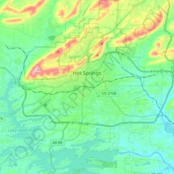
Name: Hot Springs topographic map, elevation, terrain.
Location: Hot Springs, Garland County, Arkansas, United States (34.42644 -93.12905 34.55940 -92.98510)
Average elevation: 564 ft
Minimum elevation: 302 ft
Maximum elevation: 1,378 ft
Garland County trails, hiking, mountain biking, running and outdoor activities
Make a donation
Gear up for your next adventure:
As an Amazon Associate, this site earns from qualifying purchases at no extra cost to you.
Other topographic maps
Click on a map to view its topography, its elevation and its terrain.
Make a donation
Gear up for your next adventure:
As an Amazon Associate, this site earns from qualifying purchases at no extra cost to you.
Hot Springs Village
United States > Arkansas > Garland County > Hot Springs Village
Average elevation: 741 ft
Make a donation
Gear up for your next adventure:
As an Amazon Associate, this site earns from qualifying purchases at no extra cost to you.